The Ring Road by Bicycle: A Tourism Guide for Two Fit-but-Old Dudes
Counterclockwise from Reykjavík, 2.5 weeks, fully loaded with camping gear. Matched to the "Ring take 2" route (RWGPS 53564572).
Table of Contents
- How to Read This Guide
- The Stay-Close-to-the-Road Cheat Sheet
- Chapter 1: Reykjavík to Selfoss (~60 km)
- Chapter 2: Selfoss to Vík (~130 km) — Waterfall Alley
- Chapter 3: Vík to Kirkjubæjarklaustur (~75 km) — The Sand and the Lava
- Chapter 4: Klaustur to Skaftafell (~70 km) — Approach to the Ice
- Chapter 5: Skaftafell to Höfn (~135 km) — The Glacier Lagoon Day
- Chapter 6: Höfn to Egilsstaðir (~250 km, 3 days) — The East Fjords
- Chapter 7: Egilsstaðir to Mývatn (~165 km) — The Big Empty
- Chapter 8: Mývatn to Akureyri (~100 km)
- Chapter 9: Akureyri to Blönduós (~145 km) — The Quiet North
- Chapter 10: Blönduós to Borgarnes (~150 km) — Crossing Back West
- Chapter 11: Borgarnes to Reykjavík (~75–110 km) — The Hvalfjörður Finish
- Appendix A: The Unified Food Strategy
- Appendix B: The Soak Strategy (Recovery Infrastructure)
- Appendix C: The Days-Budget, Reconciled (17 Riding Days)
- Appendix D: What We Deliberately Left Out (and Why)
- Appendix E: Photo Credits
- Index
How to Read This Guide
Every sight below gets a Cost line, priced in the three currencies that actually matter on this trip:
- Time — hours off the bike, or extra kilometers. At loaded-touring pace (call it 15 km/h moving, less into wind), a 20 km detour is an hour and a half of legs you don't get back.
- Fatigue — climbing, gravel, or wind exposure beyond what the Ring Road was already going to charge you.
- Sleep — whether visiting pushes you into a late camp setup, a noisy campground, or a short night before a long day.
The brutal math first: the Ring Road proper is ~1,330 km. With the detours worth doing you'll ride 1,400–1,450 km. In 17–18 days that's 80–85 km per day with no rest days, or ~90 km/day if you protect one rest day (take the rest day — Mývatn or Akureyri, more below). Two fit riders can do this, but it means most sights must be on-route sights. The guide is honest about which detours pay their way and which ones quietly eat a half-day you'll want back in the east fjords.
Baseline daily costs so the Cost lines make sense: campsites run roughly 2,000–3,000 ISK (~$15–22) per person and exist in every town — Iceland's 2015 land law effectively ended casual wild camping near the Ring Road, and with sites this frequent it isn't worth the friction. Every town also has a geothermal swimming pool (~1,200–1,500 ISK) which is your shower, your hot-tub recovery session, and the best people-watching in Iceland. Budget these as infrastructure, not attractions.
Wind is the tax collector. Prevailing summer winds are frequently easterly on the south coast, which is why you're pedaling into headwind country for week one and (statistically) earning tailwinds across the north. Any day the forecast says 15+ m/s, the sights section of this guide is suspended and the day's only attraction is the next windbreak. Check vedur.is like it's your job, because it is now.
Three tunnels concern you. Hvalfjörður tunnel (near Reykjavík) and Vaðlaheiðargöng (east of Akureyri) prohibit bicycles — the guide routes you around both, and both workarounds are genuinely nice. Almannaskarð tunnel (east of Höfn) allows the old pass road over the top as a scenic alternative. Details at the relevant chapters.
The Stay-Close-to-the-Road Cheat Sheet
You said it yourself: heading east first, staying near the road, but hungry for new experiences and beautiful sights. Good news — the Ring Road is the rare route where staying on it costs you almost nothing. Here is every sight in the guide, tiered by how far it drags you off Route 1. When a day goes sideways, ride Tier 1, grab Tier 2 when fresh, and let Tier 3 go without a backward glance.
Tier 1 — On the road or under 2 km off it (just stop the bike)
| Sight | Chapter | What you get |
|---|---|---|
| Urriðafoss | 2 | Iceland's biggest-volume waterfall, no crowds |
| Seljalandsfoss + Gljúfrabúi | 2 | Walk behind one fall, wade into another |
| Skógafoss | 2 | The perfect waterfall; camp at its base |
| Vík / Reynisdrangar | 2 | Sea stacks, black beach below town |
| Eldhraun moss lava | 3 | 30 km of it, from the saddle |
| Kirkjugólf | 3 | Basalt "church floor," 400 m walk |
| Lómagnúpur + Vatnajökull wall | 4 | The approach view, all day |
| Skaftafell | 4 | Trailhead campsite right off Route 1 |
| Jökulsárlón + Diamond Beach | 5 | Icebergs both sides of the road bridge |
| Hvalnes / Eystrahorn | 6 | Road pinned between mountain and sea |
| Eggin í Gleðivík | 6 | 34 granite eggs, Djúpivogur harbor |
| Hverir / Námaskarð | 7 | Boiling mud, roaring vents, roadside |
| Mývatn lake loop | 7 | Craters, lava castles, baths — all near camp |
| Goðafoss | 8 | The gods' waterfall, beside the N1 |
| Víkurskarð pass | 8 | The mandatory-but-lovely tunnel bypass |
| Öxnadalsheiði | 9 | Ring Road's high point, jagged spires |
| Staðarskáli | 10 | The hot dog of national significance |
| Grábrók crater | 10 | Rim walk right off the road |
| Settlement Center, Borgarnes | 10 | Saga storytelling, in town |
| Hvalfjörður shoreline | 11 | Car-free fjord finish (the tunnel ban's gift) |
Tier 2 — Short detours, ≤ 16 km round trip (take when legs allow)
| Sight | Chapter | RT km | Verdict |
|---|---|---|---|
| Fjaðrárgljúfur canyon | 3 | 6 | Yes — best short detour on the south coast |
| Fjallsárlón lagoon | 5 | 4 | Yes — Jökulsárlón without the bus fleet |
| Sólheimajökull | 2 | 8 | If skipping a Skaftafell glacier walk |
| Möðrudalur / Fjallakaffi | 7 | 8 (gravel) | Yes — only food for 100 km |
| Reynisfjara black beach | 2 | 10 | Yes — respect the waves |
| Dyrhólaey arch | 2 | 12 | If puffin season and legs agree |
| Glaumbær turf farm | 9 | 8 | Yes — the better turf museum |
| Stokksnes / Vestrahorn | 5 | 9 (fee) | Only with sunset energy to burn |
| Krafla / Víti | 7 | 16 | Optional — Hverir already delivered |
| Hauganes (whales, hot tubs) | 9 | 14 | The low-cost whale answer |
Tier 3 — The far ones (admire from the verdict line)
| Sight | Chapter | Cost | Verdict |
|---|---|---|---|
| Golden Circle | 1 | 2 days | Skip; grab Kerið (+25 km) at most |
| Seyðisfjörður | 6 | Full day, 600 m pass ×2 | Only if Öxi banked you a day |
| Dettifoss | 7 | Half-day+, remote, windy | Skip; Goðafoss consoles |
| Húsavík | 8 | Full day | Skip; whale-boat from Akureyri/Hauganes |
| Vatnsnes / Hvítserkur | 9 | 50+ km washboard | Skip at day 14 |
| Reykholt cluster | 10 | Half-day+ | Only if ahead of schedule |
| Glymur hike | 11 | Half-day on foot | Legs' choice at trip's end |
The counterclockwise scorecard, for morale: of the twenty Tier 1 sights, you bought nineteen of them just by riding the loop you already planned. Iceland arranged its best scenery along its only highway; you are the audience the arrangement was for.
Chapter 1: Reykjavík to Selfoss (~60 km)
Reykjavík itself (before you leave)
Give the city one honest half-day, ideally before Day 1 rather than spending trip days on it. The hit list for someone who'll be back at the end anyway:
- Hallgrímskirkja — the rocket-ship church whose facade mimics basalt columns; you'll spend two weeks seeing the real basalt it's quoting. Take the elevator up the tower (~1,400 ISK); the view of the colored roofs is the best orientation to the city you'll get.
- Bæjarins Beztu Pylsur — the harborside hot dog stand, operating since
- Order "eina með öllu" (one with everything): crispy fried onion, raw onion, ketchup, sweet mustard, remoulade. At ~700 ISK it is the only cheap restaurant meal in Iceland and it's genuinely good. This matters because the pylsa is about to become a food group for you — every N1 station on the Ring Road sells the same dog, and now you know the correct order.
- Sundhöllin — the old Art Deco indoor/outdoor pool downtown. Learn the pool ritual here (shoes off, thorough naked pre-shower, then soak): you'll repeat it in fifteen towns.
Cost: Zero if done on arrival day. As a trip day it costs a full day against an already-tight 17.
Getting out of town: the Hellisheiði question
Two ways over the plateau to Selfoss:
- Route 1 over Hellisheiði — direct, 370 m summit, but it's the busiest stretch of road in Iceland outside the capital, with heavy traffic. There is a decent shoulder most of the way, and a separated old road/path for portions. Doable but charmless.
- Þrengsli (Route 39) — slightly longer, dramatically quieter, rejoins near Þorlákshöfn side and comes into Selfoss from the south. Most cycle tourists take this and don't regret it.
Cost: Þrengsli adds ~10 km but subtracts most of the traffic stress. Take the trade. Fatigue: one honest 300 m+ climb either way, on fresh legs.
The Golden Circle detour — the big early decision
Þingvellir, Geysir, and Gullfoss form the most famous loop in Iceland, and they sit north of your route. By bike from Selfoss it's a 130–150 km inland loop (Selfoss → Kerið → Geysir → Gullfoss → back via Skálholt), i.e., two full riding days added to the trip.
What you'd get:
- Þingvellir — the rift valley where the North American and Eurasian plates visibly pull apart, and where the Alþingi (world's oldest surviving parliament) met from 930 AD. Walking the Almannagjá fissure is legitimately moving. (Farthest from your route; realistically the piece you'd cut.)
- Geysir — the geyser that named them all is mostly dormant, but Strokkur next door erupts 20–30 m every 5–10 minutes, reliable as a bus schedule. Free.
- Gullfoss — a two-tier, 32 m waterfall thundering into a slot canyon. Spectacular — but you are about to spend a week on a coast that throws a world-class waterfall at you every 40 km without leaving the road.
- Kerið — a red-and-green scoria crater lake right on Route 35, the cheapest piece of the circle to grab (small entry fee, ~600 ISK).
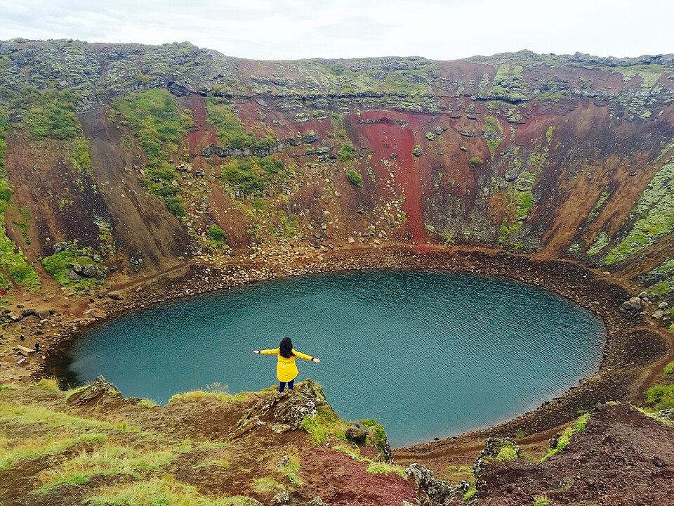
Cost: 2 days, ~1,000+ m of extra climbing, and inland wind exposure. On a 17-day clock this is the single most expensive decision of the trip. Recommendation: skip it, or grab only Kerið (a modest detour up Route 35 from Selfoss, +25 km round trip). If you've never seen Iceland before and can stretch to 18 riding days, Geysir+Gullfoss as an unloaded out-and-back from a two-night Selfoss camp is the least-bad version. The south coast will console you.
Selfoss
Biggest town until Höfn. Do your first big grocery load here — Bónus and Krónan (the budget chains; look for the pig and the... other pig) are both in town, and prices only rise as you go east. The old town center was redeveloped recently into a food-hall district; the bakery there does proper kleinur (Icelandic twisted doughnuts) and dark rye.
Cost: None — you're passing through anyway. Camp here or push on to Hella to bank kilometers.
Chapter 2: Selfoss to Vík (~130 km) — Waterfall Alley
This is the stretch that sells Iceland posters, and almost everything is within 500 m of the road. It's also the most touristed pavement in the country — expect camper vans, tour buses, and no shoulder in places. Ride it midweek if the calendar allows; mornings are far quieter at every stop.
- Urriðafoss (just off Route 1, 1 km detour) — Iceland's highest-volume waterfall, almost nobody stops. Wide, low, powerful, and you might have it to yourself. Cost: 15 minutes. The best value-per-minute stop of the week.
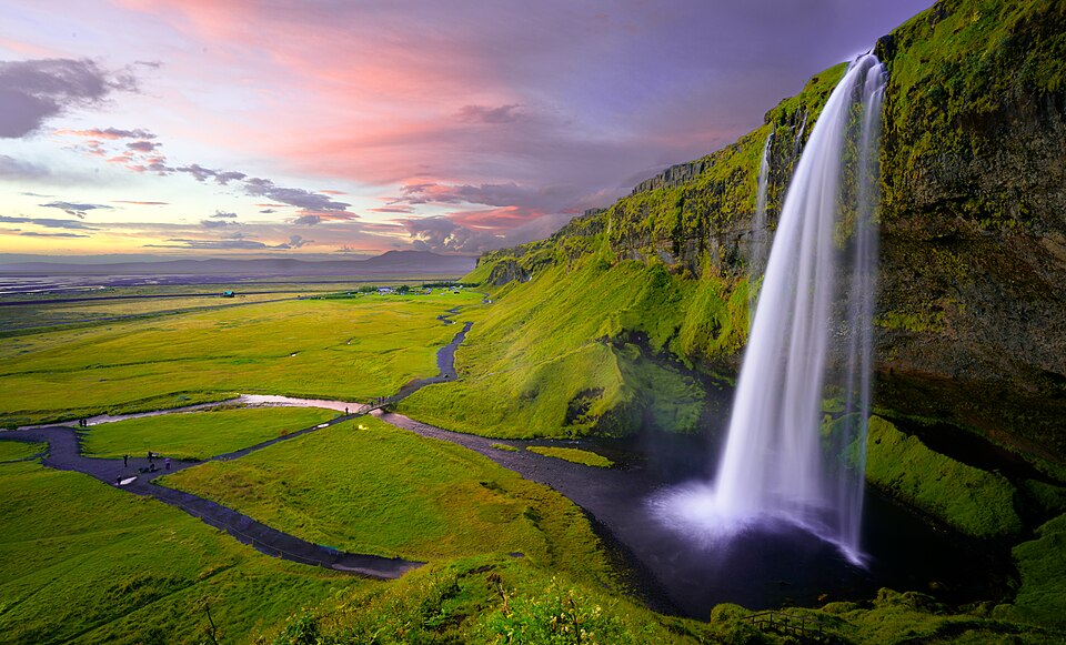
- Seljalandsfoss — the one you can walk behind: a 60 m ribbon pouring off the old sea cliff with a path circling behind the curtain. Bring the rain shell you're already carrying; the spray is a power wash. 200 m north on the same path, Gljúfrabúi hides inside a slot canyon — you wade the ankle-deep stream between the walls into a mossy chamber with the fall crashing inside. Half the crowd of Seljalandsfoss, twice the magic. Paid parking for cars; bikes roll past the machine for free, one of many small moments where the touring cyclist wins. Cost: 45–60 min for both, right on route. Non-negotiable stop.
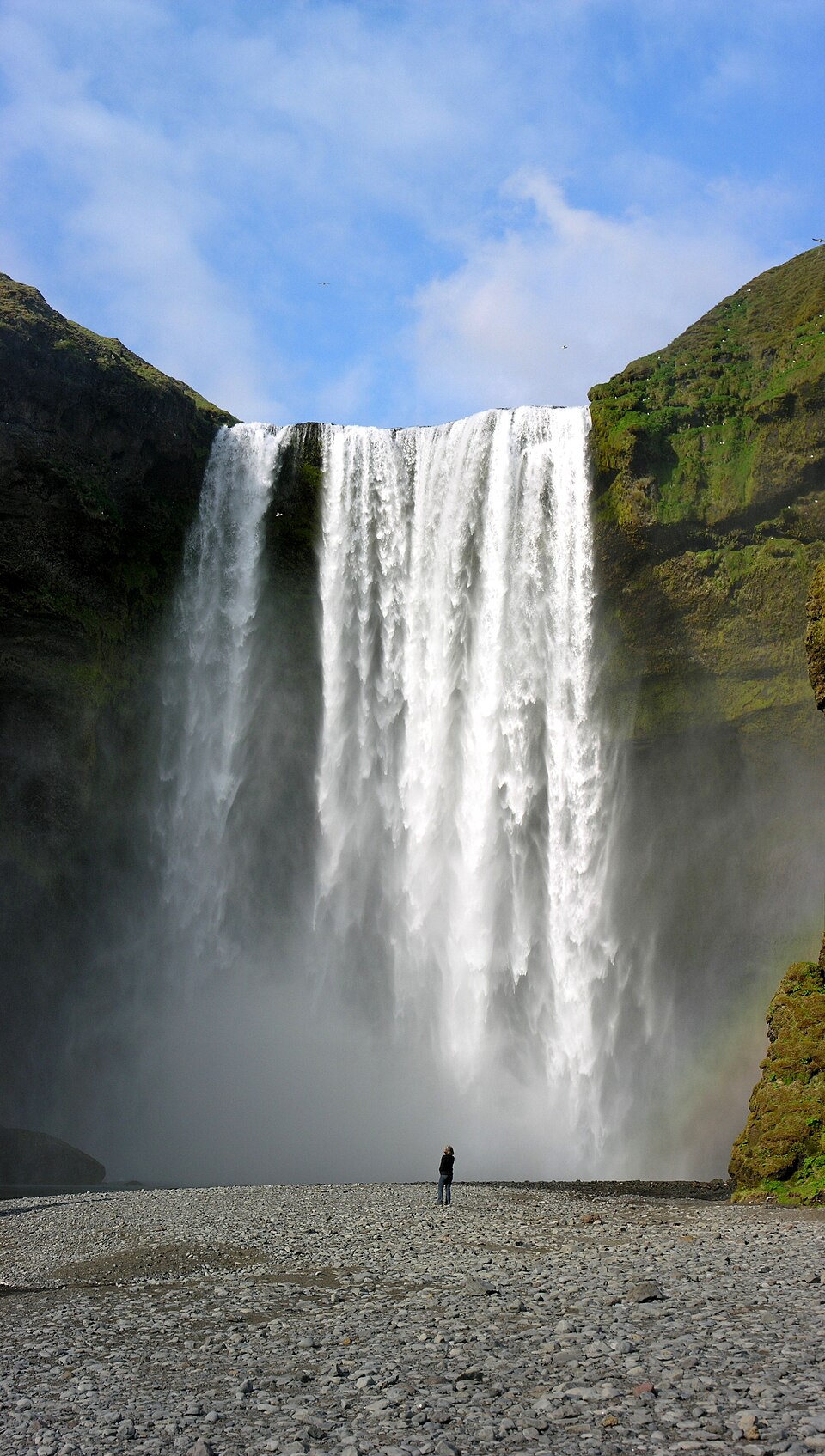
- Skógafoss — 25 km on: a 60 m, 25 m-wide, perfectly rectangular curtain of water you can walk right up to, with a permanent double rainbow in any sun. A metal staircase (~430 steps) climbs to the lip; above it, the Fimmvörðuháls trail follows the Skógá river past a chain of 20-odd smaller falls — even 2 km up and back is gorgeous. There's a campsite literally at the base of the falls. Camping with Skógafoss as your white-noise machine is a trip highlight... Sleep cost: ...and the white noise is real. It's also a busy, social campground. Earplugs (which you want for wind anyway) fix it. The Skógar Folk Museum next door (~2,500 ISK, 1–1.5 hr) has turf houses and a fishing boat era exhibit — the best of the small museums on your route if you only do one. Cost: Staircase +30–40 min and one set of burning quads; museum +90 min. Camping here instead of Vík restructures your day pleasantly.
- Sólheimajökull (Route 221, +8 km round trip) — the closest you can get to a glacier tongue by bike on the south coast: 10 min walk from the lot to a wall of ash-streaked ice calving into its own lagoon. Guided crampon walks (~2–3 hr, ~13,000+ ISK) if you want to stand on it. Cost: +8 km flat-ish and an hour, or a half-day with the ice walk. Worth it if Skaftafell weather might not cooperate later; skippable if you're committed to time at Skaftafell/Jökulsárlón, which outclass it.
- Dyrhólaey (Route 218, +12 km round trip, one very steep last pitch to the upper lighthouse) — a rock arch promontory with puffins (until ~mid-August), black beaches running to the horizon both directions, and Mýrdalsjökull looming behind. May close in spring for nesting. Cost: +12 km and a 120 m grunt climb late in a long day. If the day is going badly, Reynisfjara delivers 80% of it cheaper.
- Reynisfjara (Route 215, +10 km round trip) — the black sand beach: basalt columns stacked like organ pipes (Hallgrímskirkja's source material), the Reynisdrangar sea stacks, a cave, puffins on the cliff. Take the sneaker-wave warnings seriously — tourists get dragged in and killed here; stay well up the beach and never turn your back on the ocean. Cost: +10 km flat. Do it — but note you see the sea stacks again from Vík itself, from the other side, for free.
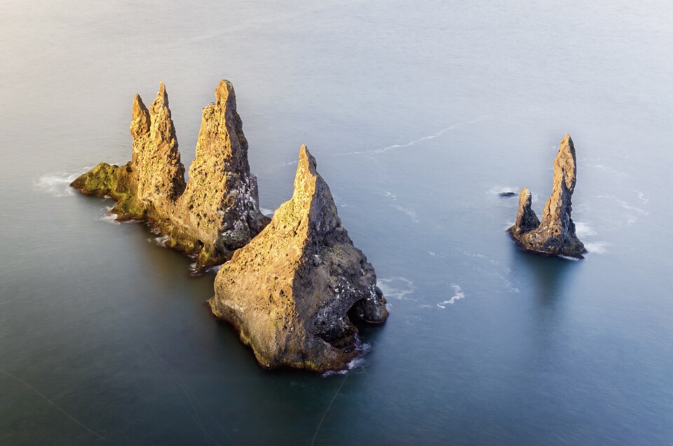
- Vík í Mýrdal — the moody little town under the bird cliff, church on the hill, sea stacks offshore. Southernmost village in Iceland and your last services for 70 km. Food: Halldórskaffi (in the old wooden Brydebúð house; solid pizza, lamb soup) or the famous soup at Suður-Vík; the N1 does the pylsa standard; there's a Krónan supermarket — restock hard. The wool factory outlet (Icewear) is the cheapest place on the route for a real Icelandic wool layer if the wind has been winning. Campsite tucked under the cliffs, grassy, sheltered. Cost: Sleep here — the day-count math wants it, and morning light on Reynisdrangar from the beach below town is free.
Chapter fatigue note: This stretch is flat to rolling, but it's where you learn what an Icelandic headwind does to a loaded bike. If an east wind is forecast, leave at dawn — wind builds through the afternoon.
Chapter 3: Vík to Kirkjubæjarklaustur (~75 km) — The Sand and the Lava
Leaving Vík you climb over the shoulder of Reynisfjall, then drop onto Mýrdalssandur — 30 km of black outwash desert deposited by Katla's eruptions. It is starkly beautiful and utterly exposed: in a west tailwind you'll fly across grinning; in an east wind it's a sandblasting cage match. There is nothing out there — no water, no shelter. Top up bottles in Vík.
Then the road enters Eldhraun, the 1783 Laki lava flow — 565 km² of lava (the largest flow in recorded history; its haze famine killed a fifth of Iceland and messed up European weather for years) now buried under a half-meter of impossibly soft gray-green moss. Rolling through it is like cycling across a becalmed ocean. Don't walk on the moss; it takes decades to heal.
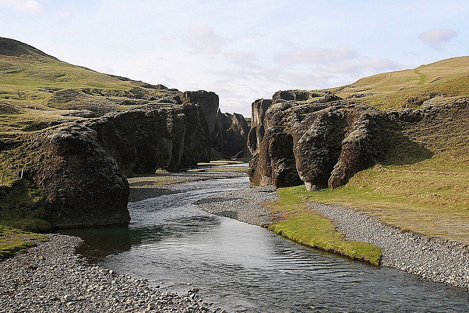
- Fjaðrárgljúfur (Route 206, +6 km round trip, last bit gravel) — a 100 m-deep, 2 km serpentine canyon with a rim path and viewing platforms, carved into palagonite so the walls look hand-molded. Justin Bieber filmed a video here and visitation exploded; it's still worth it. Cost: +6 km, ~1 hr with the rim walk, a little washboard gravel. Yes.
- Kirkjubæjarklaustur ("Klaustur" to everyone) — tiny convent-village with an outsized story: pagan-proof land, Katla legends, and Kirkjugólf ("the church floor"), a natural pavement of hexagonal basalt column tops planed flat by glaciers, 400 m walk from the road — five free minutes, quietly wonderful. Systrafoss falls right behind the village; the pool is small and pleasant. Systrakaffi is the restaurant (pizza/fish/lamb); there's a small Kjarval grocery and an N1. Campsite is basic but treed — actual windbreak trees, a south-coast rarity. Cost: Sleep here. It's the only real node between Vík and Skaftafell.
Chapter 4: Klaustur to Skaftafell (~70 km) — Approach to the Ice
The road crosses more Eldhraun, then the Skeiðarársandur — the huge sandur plain created by glacier floods (jökulhlaup) from Vatnajökull. In 1996 a flood took out the Ring Road bridges here; a twisted girder monument stands by the road as a reminder of who's in charge. The visual drama builds all day: first Lómagnúpur, a 767 m prow of cliff that looks Photoshopped, then the full white wall of Vatnajökull (Europe's largest ice cap) with outlet glaciers pouring through every gap in the mountains.
- Skaftafell (Vatnajökull National Park) — the green oasis wedged between glaciers, and the best hiking stop of your entire route. The big campsite (~2,500 ISK/person, showers, visitor center, small café) makes basecamp logistics trivial.
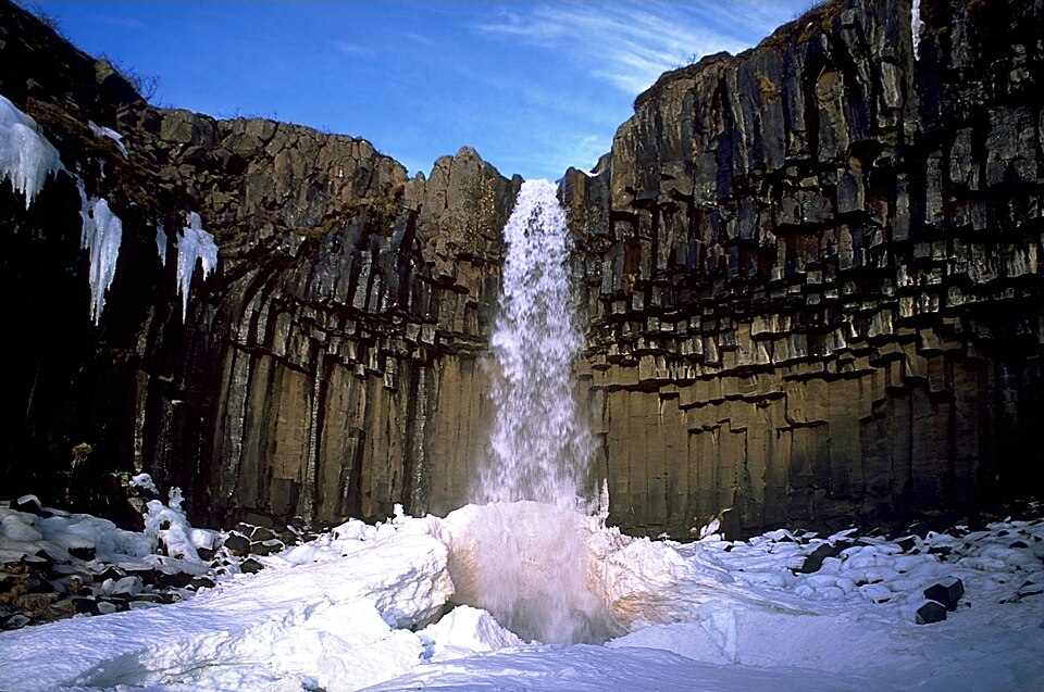
- Svartifoss — the waterfall over a colonnade of black hexagonal basalt, hanging like a pipe organ. 5.5 km round trip, ~250 m up, 1.5–2 hr at a saunter.
- Sjónarsker / Sjónarnípa viewpoint extension — add 3–4 km for a full-frontal view down onto Skaftafellsjökull's crevasse field. This upgrade is the best hiking hour on the south coast.
- Glacier walks on Falljökull/Svínafellsjökull run from here too (3 hr, ~15,000 ISK) — better ice than Sólheimajökull if you're doing one guided walk on the trip. Cost: In time, an afternoon+overnight, or a full extra day with a glacier walk. In fatigue, the hikes are mercifully not on the bike and use different muscles — it genuinely functions as active recovery. Sleep: the campsite is big and can be windy, but it's well-run. Strong recommendation: arrive by early afternoon, hike Svartifoss loop in the evening light, sleep, roll at dawn.
Chapter 5: Skaftafell to Höfn (~135 km) — The Glacier Lagoon Day
The single most scenic riding day of the trip, and one of the most scenic cycling days available anywhere. Glacier tongues appear on your left every few kilometers all day. It's also long — consider splitting it (options below).
- Fjallsárlón (+2 km, signed) — Jökulsárlón's little sibling: a lagoon crammed with bergs right under the glacier snout, 10% of the crowds. If you stop only once before the big one, stop here for the intimacy. Cost: 30 min.
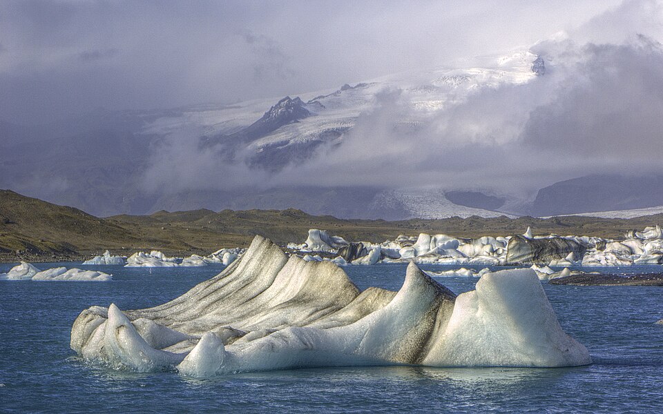
- Jökulsárlón — on the road; the Ring Road bridge crosses the lagoon outlet. Icebergs calved from Breiðamerkurjökull — luminous blue, ash- striped, seal-dotted — drift toward the sea for years before escaping. Across the road, Diamond Beach: the escaped bergs wash back up on jet-black sand and sit there like jewelry until they melt. Boat tours (zodiac ~13,000+ ISK, amphibian cheaper) get you among the ice, but the shore show is free and honestly sufficient. There's a food van cluster (the humarsúpa/lobster-soup van is the classic). Cost: Zero detour; 1–2 hr of gawking will happen whether you plan it or not. Budget it. If splitting the day, there's no camping here — nearest legal camp back at Skaftafell/Svínafell or ahead at Höfn, which is exactly why this day runs long.
- The stretch onward rounds Almannaskarð. The pass road (old Route 1) over the top is open to you where the tunnel is not required for bikes — short, steep, and with a panoramic collapse-view over the Höfn lagoons and Stokksnes; or take the flat tunnel if it's open to bikes and the day has been enough. (Check locally; the old pass is the scenic answer.)
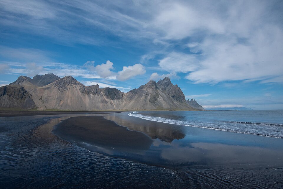
- Stokksnes / Vestrahorn (+9 km round trip on the private Viking Café road, small fee ~900 ISK) — the spiky batwing mountain rising from a black dune beach, the most photographed "metal album cover" in Iceland. Cost: +9 km at the exhausted end of a 135 km day. Photographers' answer: yes, at sunset, absolutely. Tired cyclists' answer: you already saw it in profile from the road for free. Decide with your legs.
- Höfn — langoustine capital of Iceland. This is the designated earned restaurant meal of the trip: Pakkhús (the harbor warehouse; langoustine tails in garlic butter, ~7,000–9,000 ISK and worth every krona) or Hafnarbúðin, the humble harborside grill, for a langoustine baguette and humarsúpa at half the price. Nettó supermarket for restock. The campsite is large, flat, and functional; the pool has hot pots with a Vatnajökull view. Cost: Sleep here, eat the langoustine, feel no guilt. You just rode the best 135 km of your life.
Chapter 6: Höfn to Egilsstaðir (~250 km, 3 days) — The East Fjords
The forgotten quarter — and the payoff of going counterclockwise, because you hit it acclimatized. Traffic drops to a fraction of the south coast. The road hugs cliff-foot shorelines, rounds one fjord after another, and every village has 300 people, a pool, and a story.
- The Hvalnes / Eystrahorn stretch — Vestrahorn's twin at the far end of the Lón lagoon, with the road pinned between scree and sea. One of the great quiet road sections; the lighthouse point is a 5-minute stop.
- Djúpivogur — slow-food-certified village ("Cittaslow," which suits a bicycle). Eggin í Gleðivík: 34 oversized granite eggs by sculptor Sigurður Guðmundsson lining the old harbor road, one per local nesting bird species — free, charming, 15 minutes. Campsite, pool, small store, and Við Voginn for fish and chips at the harbor. Cost: On route. A natural sleep node.
The Öxi decision (the east's big fork)
From Berufjörður's head, mountain road 939 (Öxi) cuts straight to Egilsstaðir: saves ~60 km but climbs to 530 m on steep gravel (grades to 17%). The Ring Road proper now stays on pavement around the coast through Breiðdalsvík and up the valleys.
- Öxi: −60 km, +1 brutal climb, gravel descent with loaded bikes, waterfalls all the way up, huge views. In good weather: a hard, glorious half-day and a net time save.
- Coast route: +60 km but you collect Breiðdalsvík (Kaupfjelagið, a lovely old general store/café; Beljandi brewery — the east's little craft taproom) and optionally Stöðvarfjörður with Petra's Stone Collection (~1,500 ISK) — a lifetime of one woman's rock-hounding, an entire garden crusted in jasper, agate, and zeolites. Kitschy-sounding, genuinely delightful, the east fjords' best small attraction.
Cost verdict: In fine, dry weather with legs to burn, Öxi is the adventure and buys you back most of a day — spendable on Seyðisfjörður (below). In wind, rain, or fatigue debt, the coast is safer, prettier per pedal stroke, and has the stone lady. You genuinely can't lose; pick with the forecast.
- Egilsstaðir — the east's service hub on the Lagarfljót river; big Bónus/Nettó restock (the best grocery stop between Selfoss and Akureyri), campsite, pool. The lake allegedly hosts a wyrm-monster (Lagarfljótsormurinn) with sightings since 1345 — scan the water while you eat skyr. Vök Baths (+5 km, ~7,000 ISK) float in the lake north of town — geothermal pools in the cold lake — if you want the fancy soak without the Blue Lagoon's price-and-crowds.
The Seyðisfjörður detour
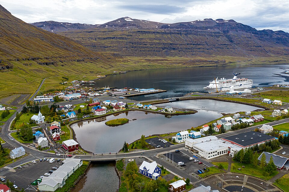
+27 km each way over a 600 m pass (Fjarðarheiði) to the prettiest village in the east: rainbow-painted street to a blue wooden church, Norwegian kit houses, waterfall staircase (Gufufoss) beside the climb, artist community, the ferry from Europe docking among it all.
Cost: the priciest single detour on your route — 54 km round trip and 600 m of climbing each direction (you climb both ways; the pass is between you and everything). That's a full day, or an overnight with camp at the village site. Verdict: if Öxi bought you a day, spend it here and it balances; otherwise admire the postcards. (No judgment either way — plenty of strong tourers skip it and don't die of regret.)
Chapter 7: Egilsstaðir to Mývatn (~165 km) — The Big Empty
The most remote leg: the road climbs to the Jökuldalsheiði highland plateau (500–600 m) and stays high, crossing stone-and-lichen desert where the view is 40 km of nothing in every direction, punctuated by steam plumes. Services are nearly nil — this is a stage to respect.
- Wind/weather cost note: this plateau is the most exposed riding of the trip; in a westerly it is a two-day slog and there's no shame in splitting it. Water is scarce; carry a full day's worth.
- Möðrudalur / Fjallakaffi (+8 km round trip on gravel, signed) — the highest farm in Iceland (469 m), a tiny turf-roofed church built by a farmer in memory of his wife, and Fjallakaffi, serving kleinur, cakes, and lamb soup in the absolute middle of nowhere. There's also a small campsite — the strategic mid-stage sleep if you split the leg. Cost: +8 km gravel; as a lunch stop it's the only game for 100 km and doubles as morale insurance. Take it.
- Dettifoss (Route 862, +50–56 km round trip from the junction) — Europe's most powerful waterfall: 100 m wide, 45 m drop, gray glacial water throwing spray you can see from kilometers away. Cost: This is the detour that breaks hearts. It's a half-day-plus at the far end of your longest empty stage, into likely wind. If the budget allows exactly one big out-and-back in the north, most riders are happier banking the rest day instead. Verdict: only if you've split the stage at Möðrudalur and the day is calm. Otherwise Goðafoss (free, on-route, ahead) is your consolation and it's a good one.
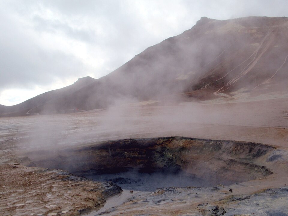
- Námaskarð / Hverir — as you crest the pass above Mývatn, the ground turns orange-and-sulfur: boiling mud pots, roaring steam vents, the smell of the underworld. It's right on the road. Walk the boardwalks. Cost: free, 30–45 min, zero detour. One of Iceland's weirdest free attractions.
- Krafla / Víti (+16 km round trip, paved, ~200 m up past the geothermal plant's steam-pipe arch) — the Krafla fires' crater row and Víti, a turquoise crater lake ("Víti" = Hell; Iceland names things honestly). Cost: +16 km and real climbing right before day's end. Nice-to-have; Hverir already gave you the geothermal show for free.
Mývatn — the rest-day argument
A shallow, bird-thronged lake in a volcanic playground; everything below is within a 36 km lakeside loop, which is a perfect unloaded rest-day ride (leave the panniers in the tent — the bike feels like a rocket):
- Dimmuborgir — "the dark castles": a collapsed lava-lake maze of arches and towers with easy loop trails. Folklore says the Yule Lads live here. Free; 1 hr.
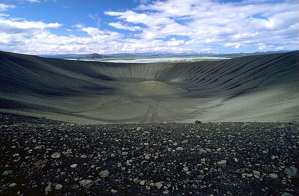
- Hverfjall — a 1 km-wide, textbook-perfect tephra crater; 20 min switchback grind to the rim, walk the full circle for lake-and-lava panoramas. Free.
- Grjótagjá — the fissure cave with a steaming blue pool (Game of Thrones fame; bathing no longer allowed, peeking free).
- Skútustaðagígar pseudocraters — grassy bubble-craters along the south shore, formed when lava flowed over wetland and the steam blew rings in it.
- Mývatn Nature Baths — the north's Blue Lagoon (milky blue silica water in a hillside lagoon) at roughly half the Blue Lagoon's price (~7,000–8,000 ISK) and a tenth of the self-importance. As a rest-day finale for old touring muscles, this is the best-spent money of the trip.
- Food: Vogafjós — a working cowshed café/restaurant (you eat next to the milking parlor, glass wall and all): house-smoked char, geysir bread baked in geothermal ground, their own mozzarella. The north's best meal. The Cowshed camp and the Bjarg campsite at Reykjahlíð both work; Reykjahlíð has the store (Samkaup, small and pricey — you restocked at Egilsstaðir, right?).
- Midge warning: Mývatn means "midge lake" and it earns the name in July. They don't bite (mostly) but they swarm. A cheap head net weighs nothing — buy one in Reykjavík and be the smuggest man on the lakeshore.
Cost: The rest day here costs one calendar day and buys back measurable legs, laundry, and morale for the final week. Strongly recommended over pushing through.
Chapter 8: Mývatn to Akureyri (~100 km)
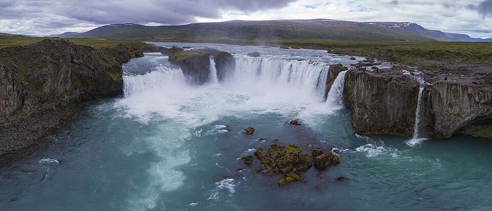
- Goðafoss — 50 km along, right beside the road: the "waterfall of the gods," a 30 m horseshoe where, per the saga, the lawspeaker Þorgeir threw his pagan idols after Iceland's conversion in 1000 AD. Paths to both rims; the café/N1 at Fosshóll does the pylsa-and-coffee standard. Cost: free, zero detour, 30–45 min. The consolation Dettifoss, and a fine one.
- The Vaðlaheiðargöng problem: the new tunnel into Akureyri prohibits bicycles. You ride the old road over Víkurskarð (~325 m) instead — quiet since the tunnel opened, gentle grades, and a grand reveal of Eyjafjörður from the top. The old road is the better road; the tunnel toll-payers are the ones missing out. Cost: +~10 km and one moderate climb versus the forbidden tunnel. Not optional, but not a hardship.
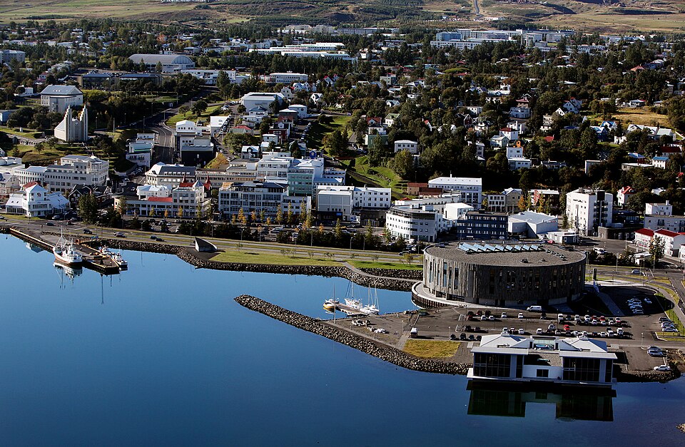
- Akureyri — Iceland's second city (pop. ~20,000, which after the east fjords will feel like Manhattan). The traffic lights have heart-shaped red lights (a post-2008-crash morale project — really).
- Brynja ice cream (since 1939) — the north's legendary ice cream; order the old-fashioned vanilla soft serve with a dip. Cyclist's portion: yes.
- Botanical Garden — surprisingly lovely at 65°N, free.
- Akureyrarkirkja — Hallgrímskirkja's architect again, basalt motif again, 112 steps up from the shopping street.
- The swimming pool is one of Iceland's best: multiple hot pots, steam, water slides you are not too old for.
- Real supermarkets (Bónus, Nettó), bike shops (the only real ones since Reykjavík/Selfoss — get anything creaking looked at NOW), bakeries (Kristjáns bakarí), and the Hof cultural center. Cost: Sleep here (good town campsite by the pool). If you didn't rest at Mývatn, rest here — resupply and repair value is highest at this node.
The Húsavík question
Whale watching's world capital sits +45 km off-route (each way) via Route 85 from near Goðafoss. Humpback sighting rates in Skjálfandi Bay run ~95%+ in summer; the wooden-schooner tours (Gentle Giants / North Sailing, ~11,000–13,000 ISK, 3 hr) are the best whale trips in Europe, and the Whale Museum and GeoSea clifftop baths are both excellent.
Cost: ~90 km round trip = a full extra day. Alternative: whale tours also run from Akureyri itself (Eyjafjörður humpbacks, very good rates, zero detour) or Hauganes (Iceland's oldest operation, 35 km north of Akureyri on your route — see Chapter 9). Verdict: skip the Húsavík detour; do the fjord tour from Akureyri or Hauganes and pocket the day.
Chapter 9: Akureyri to Blönduós (~145 km) — The Quiet North
Out of Eyjafjörður the Ring climbs Öxnadalsheiði (~540 m, the highest point of the entire Ring Road) through a valley of jagged spires — Hraundrangi's needle summit was long thought unclimbable. Long steady grades, not steep; the descent west is a gift.
- Hauganes (+7 km off-route before the climb, if doing the whale tour here) — also home to Baccalá Bar, a salt-cod shack with fjord-side hot tubs. The kind of stop that becomes the story you tell.
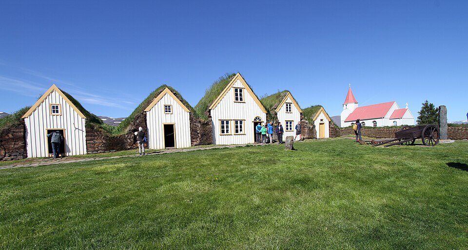
- Varmahlíð — crossroads hamlet; from here Icelandic-horse country radiates. Glaumbær (+8 km round trip north on 75) — the best preserved turf farmhouse complex in Iceland (~2,500 ISK): a whole 19th-century farm under grass roofs, rooms left as lived-in. If you skipped the Skógar museum, do this one; if you did Skógar, this is the better half of the pair anyway. Cost: +8 km flat, 1 hr.
- Horse people: several farms around Varmahlíð/Skagafjörður do 1–2 hr Icelandic horse rides (~10,000 ISK) — the tölt gait is a genuine novelty and, warning, uses exactly the muscles cycling spared.
- Blönduós — functional river-mouth town: campsite on the island in the river (nice), pool, Kjörbúðin grocery, N1. Cost: a sleep node, not a sight. That's fine; today was about the pass.
Skippable with a clear conscience: the Vatnsnes peninsula loop (Hvítserkur sea stack, seal colonies) — 50+ km of washboard gravel loop; lovely, but at day 14 of 17 the fatigue ledger says no.
Chapter 10: Blönduós to Borgarnes (~150 km) — Crossing Back West
One more big shoulder: Holtavörðuheiði (~410 m, long and gradual). The N1 at Staðarskáli at its northern foot is the most famous truck stop in Iceland — every Icelander alive has eaten a hot dog here; join them. South of the pass, the land softens into Borgarfjörður's saga country.
- Grábrók (right on Route 1) — a 170 m scoria crater with a stair path to the rim, 30 min up-and-around, free, and the road threads its lava field. Perfect legs-stretcher.
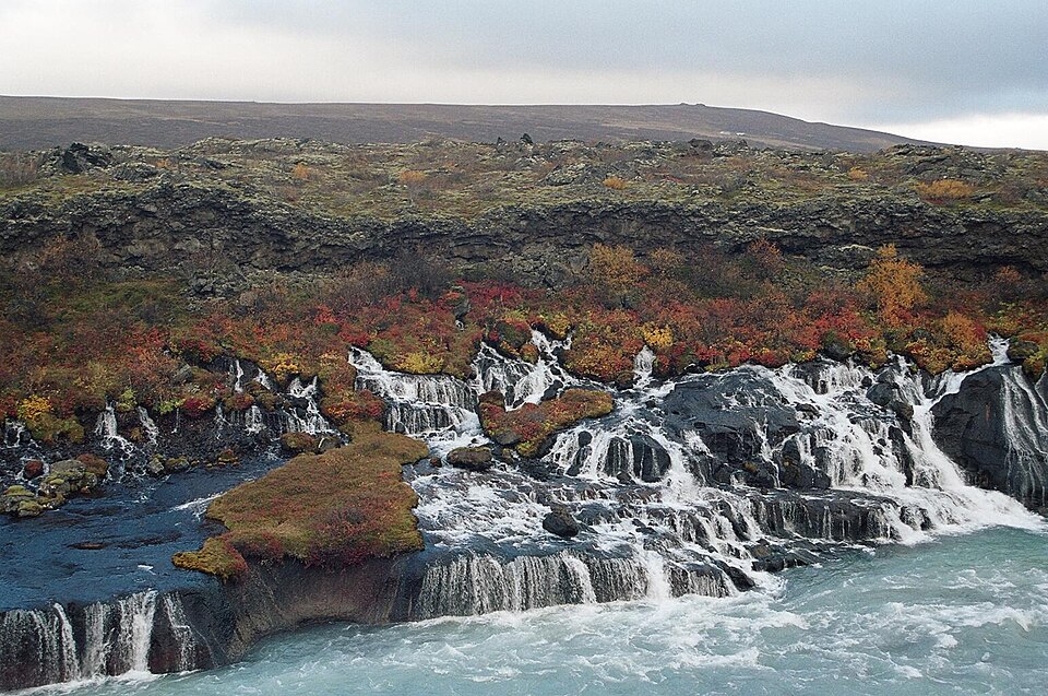
- Optional Reykholt cluster (+25–35 km via Routes 50/518): Deildartunguhver, Europe's highest-flow hot spring (a hillside literally boiling over, plus Krauma baths beside it); Reykholt, home of Snorri Sturluson — medieval Iceland's greatest writer (the Prose Edda; also politician enough to get assassinated in his own cellar in 1241) with his (probable) original hot pool, Snorralaug, still steaming; and Hraunfossar, where a kilometer of springs pours out of the face of a lava field into the blue Hvítá — no river above, just water emerging from rock. Cost: adds a half day+; worth it only if you're ahead of schedule and the weather's kind. Hraunfossar is the star of the three.
- Borgarnes — saga central: the Settlement Center (~3,500 ISK, two 30-min exhibitions) tells the landnám (settlement) story and Egil's Saga — Egil Skallagrímsson being the Viking-poet-psychopath whose family farmed this very ground. The best narrative-history stop on the route, and dinner in the same building is good. Campsite, Bónus, pool with fjord-view hot pots. Cost: on route; give the Settlement Center 1.5 hr. Sleep here — the last night before the finish.
Chapter 11: Borgarnes to Reykjavík (~75–110 km) — The Hvalfjörður Finish
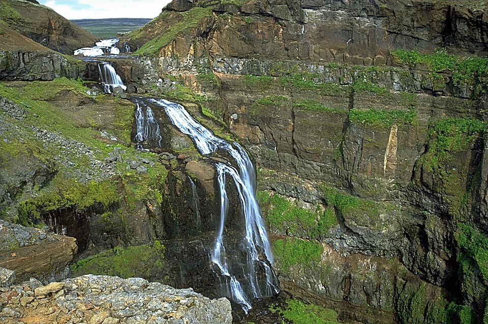
The Hvalfjörður tunnel is forbidden to bicycles, which forces the old Ring Road around Hvalfjörður fjord — and this "penalty" is the best-kept secret of the ride: ~45 extra km of nearly car-free shoreline road (everyone's in the tunnel), a WWII naval-station past, waterfalls off the cliffs, and, at the fjord's head, the trail to Glymur — Iceland's second-highest waterfall (198 m) in a mossy gorge with a log-crossing of the river (3–4 hr round trip on foot; river crossing mid-summer only).
Cost: the fjord loop adds ~45 km versus the (forbidden) tunnel line — call it 3 hours of the trip's most peaceful riding. Glymur adds a half-day of legitimate hiking with wet feet; magnificent, but at trip's end your knees get a vote. Alternative if the weather's foul or the schedule collapsed: buses through the tunnel take bikes (Strætó 57 — check the bike policy/space that morning).
Roll back into Reykjavík along the Kjalarnes shoulder (windy, the last tax) and the city's bike paths. Finish-line protocol: Sundhöllin hot pot, then Bæjarins Beztu — one with everything. You'll have earned the double.
Appendix A: The Unified Food Strategy
- Breakfast/lunch: skyr (protein-dense, cheap, everywhere), rye bread, cheese, oats. Icelandic butter is superb; carry it — it's cold enough.
- The pylsa network: every N1/Olís/Orkan grill sells the standard hot dog. It is the Ring Road's calorie currency, ~600–800 ISK.
- The bakery rule: any town big enough for a bakery, stop: kleinur, snúður (cinnamon whirl), rúgbrauð (dense sweet rye — outstanding touring fuel).
- Groceries: Bónus/Krónan/Nettó = cheap; Kjörbúðin/Samkaup = small- town normal; N1 = desperation pricing. Big loads at Selfoss, Egilsstaðir, Akureyri, Borgarnes.
- The earned meals (budget ~3 of them): langoustine in Höfn, Vogafjós at Mývatn, and one wildcard (Breiðdalsvík's Kaupfjelagið, Akureyri, or the Settlement Center in Borgarnes).
- Water: every tap and most streams; the sulfur smell in hot water is geothermal, harmless, and only in the hot tap. Cold tap is glacier-grade.
Appendix B: The Soak Strategy (Recovery Infrastructure)
Municipal pool nearly every night: Vík, Klaustur, Höfn, Djúpivogur, Egilsstaðir, Reykjahlíð, Akureyri, Blönduós, Borgarnes. ~1,200–1,500 ISK for hot pots, steam, and a proper shower. This is why two old dudes can average 85 km/day for 17 days. Premium upgrades, pick at most two: Mývatn Nature Baths (the right one), Vök (Egilsstaðir), GeoSea (Húsavík, if you go), Krauma (Reykholt, if you go). Skip the Blue Lagoon entirely — wrong side of Reykjavík, triple the price, and you'll have bathed better.
Appendix C: The Days-Budget, Reconciled (17 Riding Days)
| Day | Leg | ~km |
|---|---|---|
| 1 | Reykjavík → Selfoss (Þrengsli) | 65 |
| 2 | Selfoss → Skógar (waterfall alley) | 95 |
| 3 | Skógar → Vík (Dyrhólaey/Reynisfjara) | 40+detours |
| 4 | Vík → Kirkjubæjarklaustur | 75 |
| 5 | Klaustur → Skaftafell (evening hike) | 70 |
| 6 | Skaftafell → Höfn (Jökulsárlón!) | 135 |
| 7 | Höfn → Djúpivogur | 105 |
| 8 | Djúpivogur → Egilsstaðir (Öxi or coast+1 sleep) | 85–145 |
| 9 | Egilsstaðir → Möðrudalur | 90 |
| 10 | Möðrudalur → Mývatn (Hverir) | 75 |
| 11 | Mývatn rest day (unloaded lake loop + baths) | 36, unloaded |
| 12 | Mývatn → Akureyri (Goðafoss, Víkurskarð) | 100 |
| 13 | Akureyri → Varmahlíð (Öxnadalsheiði, Glaumbær) | 100 |
| 14 | Varmahlíð → Blönduós (short; laundry/wind buffer) | 50 |
| 15 | Blönduós → Borgarnes (Holtavörðuheiði) | 150 |
| 16 | Borgarnes → Hvalfjörður head (Glymur eve/morn) | 60 |
| 17 | Hvalfjörður → Reykjavík | 65 |
Slack in the system: days 3 and 14 are short on purpose — they're your wind-delay insurance. If the weather gods smile, day 14's surplus can fund Seyðisfjörður (via Öxi on day 8) or the Reykholt cluster on day 15. If they don't, you're still home on time.
Appendix D: What We Deliberately Left Out (and Why)
- Golden Circle by bike — 2 days against a 17-day clock (grab Kerið).
- Dettifoss — half-day into wind at the remotest point (Goðafoss consoles).
- Húsavík detour — full day (whale-boat from Akureyri/Hauganes instead).
- Vatnsnes gravel loop — day-14 knees said no.
- Blue Lagoon — wrong direction, wrong price, and Mývatn's is better for you.
- Landmannalaugar / Askja / Westfjords — not Ring trips; that's the next 2.5 weeks.
Prices are mid-2020s ballpark and drift upward; Iceland will round them in its own favor. The waterfalls, the moss, the pools, and the hot dog order are permanent.
Appendix E: Photo Credits
All photographs are from Wikimedia Commons, used under their free licenses; our thanks to the photographers.
- Kerið — Scoundrelgeo, CC BY-SA 4.0 (Commons: A_girl_standing_on_top_of_Kerið.jpg)
- Seljalandsfoss — Robert Lukeman robertlukeman, CC0 (Commons: Idyllic_landscape_with_a_waterfall_(Unsplash).jpg)
- Skógafoss — Hansueli Krapf, CC BY-SA 3.0 (Commons: 2008-05-24_35_Skógafoss.jpg)
- Reynisdrangar — Jakub Fryš, CC BY-SA 4.0 (Commons: Reynisdrangar_basalt_rocks.jpg)
- Fjaðrárgljúfur — Guillaume Baviere from Uppsala, Sweden, CC BY 2.0 (Commons: Iceland_2008-05-27_(2684049831).jpg)
- Svartifoss — Andreas Tille, CC BY-SA 4.0 (Commons: SvartifossWinter.jpg)
- Jökulsárlón — Molechaser, CC BY-SA 2.0 (Commons: Jökulsárlón_lagoon_in_southeastern_Iceland.jpg)
- Stokksnes — Daniel Oberhaus, CC BY 4.0 (Commons: Vestrahorn_and_Stokksnes_beach_in_Iceland.jpg)
- Seyðisfjörður — Kasa Fue, CC BY-SA 4.0 (Commons: Seyðisfjörður_Sept_2019_2.jpg)
- Hverir — David Stanley from Nanaimo, Canada, CC BY 2.0 (Commons: Hverir Geothermal Area (52424383117).jpg)
- Hverfjall — Andreas Tille, CC BY-SA 4.0 (Commons: HverfellInnerCrater.jpg)
- Goðafoss — Chensiyuan, CC BY-SA 4.0 (Commons: 1_Goðafoss_aerial_pano_2017.jpg)
- Akureyri — Kaldbakstindur, CC BY-SA 4.0 (Commons: Akureyri_-_Skapti_Hallgrímsson.jpg)
- Glaumbær — Gerd Eichmann, CC BY-SA 4.0 (Commons: Glaumbaer-52-Museum-Kirche-2018-gje.jpg)
- Hraunfossar — Reykholt, CC BY-SA 3.0 (Commons: Hraunfossar_2004.jpg)
- Glymur — Andreas Tille, CC BY-SA 4.0 (Commons: Glymur.jpg)
Index
Entries reference chapter numbers (App. = Appendix, HTR = How to Read This Guide).
A
- Akureyri — Ch. 8; food/repair hub, App. A
- Akureyrarkirkja (church) — Ch. 8
- Almannaskarð (pass/tunnel) — HTR; Ch. 5
- Alþingi (Þingvellir parliament) — Ch. 1
B
- Baccalá Bar (Hauganes) — Ch. 9
- Bæjarins Beztu Pylsur (hot dogs, Reykjavík) — Ch. 1, 11
- bakeries — Ch. 1 (Selfoss), Ch. 8 (Kristjáns); App. A
- Beljandi brewery (Breiðdalsvík) — Ch. 6
- bike shops — Ch. 8 (Akureyri)
- black sand beaches — Ch. 2 (Reynisfjara, Dyrhólaey), Ch. 5 (Diamond Beach)
- Blönduós — Ch. 9
- Blue Lagoon (skipping it) — App. B, App. D
- Bónus / Krónan / Nettó (groceries) — Ch. 1, 6, 8, 10; App. A
- Borgarnes — Ch. 10
- Botanical Garden (Akureyri) — Ch. 8
- Breiðdalsvík — Ch. 6
- Brynja ice cream (Akureyri) — Ch. 8
- buses (bikes through tunnels) — Ch. 11
C
- campsites (economics, law) — HTR
- cheat sheet (sights tiered by distance off-route) — Stay-Close Cheat Sheet
- Cost system (time / fatigue / sleep) — HTR
- counterclockwise (direction rationale) — HTR; Ch. 6
- craters — Ch. 1 (Kerið), Ch. 7 (Hverfjall, Víti), Ch. 10 (Grábrók)
D
- Deildartunguhver (hot spring) — Ch. 10
- Dettifoss (and why to skip it) — Ch. 7; App. D
- Diamond Beach — Ch. 5
- Dimmuborgir — Ch. 7
- Djúpivogur — Ch. 6
- Dyrhólaey — Ch. 2
E
- Eggin í Gleðivík (egg sculptures) — Ch. 6
- Egilsstaðir — Ch. 6
- Egil's Saga / Settlement Center — Ch. 10
- Eldhraun (Laki lava field, moss) — Ch. 3, 4
- Eystrahorn / Hvalnes — Ch. 6
F
- Fjaðrárgljúfur (canyon) — Ch. 3
- Fjallakaffi (Möðrudalur) — Ch. 7
- Fjallsárlón (glacier lagoon) — Ch. 5
- Fimmvörðuháls trail (lower falls) — Ch. 2
G
- Geysir / Strokkur — Ch. 1
- GeoSea baths (Húsavík) — Ch. 8; App. B
- glacier walks — Ch. 2 (Sólheimajökull), Ch. 4 (Skaftafell)
- Glaumbær (turf farm) — Ch. 9
- Gljúfrabúi (hidden waterfall) — Ch. 2
- Glymur (waterfall/hike) — Ch. 11
- Goðafoss — Ch. 8
- Golden Circle (verdict: skip/trim) — Ch. 1; App. D
- Grábrók crater — Ch. 10
- Grjótagjá (fissure cave) — Ch. 7
- Gullfoss — Ch. 1
H
- Hallgrímskirkja — Ch. 1
- Halldórskaffi (Vík) — Ch. 2
- Hafnarbúðin (Höfn) — Ch. 5
- Hauganes (whales, salt cod, hot tubs) — Ch. 8, 9
- Hellisheiði vs Þrengsli (routes out of Reykjavík) — Ch. 1
- Höfn (langoustine) — Ch. 5
- Holtavörðuheiði (pass) — Ch. 10
- horse riding (Icelandic horses, tölt) — Ch. 9
- hot dogs (pylsa) — Ch. 1, 10, 11; App. A
- Hraunfossar — Ch. 10
- humarsúpa (lobster/langoustine soup) — Ch. 5
- Húsavík (whale watching; verdict) — Ch. 8; App. D
- Hvalfjörður (fjord loop, forbidden tunnel) — HTR; Ch. 11
- Hverfjall crater — Ch. 7
- Hverir / Námaskarð (geothermal field) — Ch. 7
- Hvítserkur / Vatnsnes (skipped) — Ch. 9; App. D
J
K
- Kerið crater — Ch. 1
- Kirkjubæjarklaustur ("Klaustur") — Ch. 3
- Kirkjugólf (basalt "church floor") — Ch. 3
- kleinur (doughnuts) — Ch. 1, 7; App. A
- Krafla / Víti — Ch. 7
- Krauma baths — Ch. 10; App. B
L
- Lagarfljótsormurinn (lake monster) — Ch. 6
- Laki eruption (1783) — Ch. 3
- langoustine — Ch. 5 (Höfn)
- Lómagnúpur (cliff) — Ch. 4
M
- midges (head net) — Ch. 7
- Möðrudalur (highest farm) — Ch. 7
- moss (don't walk on it) — Ch. 3
- Mýrdalssandur (black desert crossing) — Ch. 3
- Mývatn (lake, rest day) — Ch. 7
- Mývatn Nature Baths — Ch. 7; App. B
N
O / Ö
P
- Pakkhús (Höfn) — Ch. 5
- Petra's Stone Collection (Stöðvarfjörður) — Ch. 6
- photo credits — App. E
- pools, municipal (ritual, strategy) — Ch. 1; App. B
- puffins — Ch. 2 (Dyrhólaey, Reynisfjara)
- pylsa — see hot dogs
R
- rest day (the argument for) — HTR; Ch. 7
- Reykholt / Snorri Sturluson — Ch. 10
- Reykjavík — Ch. 1, 11
- Reynisfjara (sneaker-wave warning) — Ch. 2
- Reynisdrangar (sea stacks) — Ch. 2
S
- Seljalandsfoss — Ch. 2
- Selfoss — Ch. 1
- Settlement Center (Borgarnes) — Ch. 10
- Seyðisfjörður (detour verdict) — Ch. 6
- Skaftafell (Vatnajökull NP) — Ch. 4
- Skeiðarársandur (flood plain, bridge monument) — Ch. 4
- Skógafoss / Skógar Folk Museum — Ch. 2
- Skútustaðagígar (pseudocraters) — Ch. 7
- skyr — Ch. 6; App. A
- sneaker waves — Ch. 2 (Reynisfjara)
- Sólheimajökull — Ch. 2
- Staðarskáli (truck stop) — Ch. 10
- Stokksnes / Vestrahorn — Ch. 5
- Stöðvarfjörður — Ch. 6
- Sundhöllin (Reykjavík pool) — Ch. 1, 11
- Svartifoss — Ch. 4
- Systrakaffi / Systrafoss (Klaustur) — Ch. 3
T / Þ
- Þingvellir — Ch. 1
- Þrengsli (Route 39) — Ch. 1
- tunnels (bicycle prohibitions) — HTR; Ch. 5, 8, 11
- turf houses — Ch. 2 (Skógar), Ch. 7 (Möðrudalur), Ch. 9 (Glaumbær)
U
- Urriðafoss — Ch. 2
V
- Vaðlaheiðargöng (forbidden tunnel) / Víkurskarð (old pass) — Ch. 8
- Varmahlíð — Ch. 9
- Vatnajökull — Ch. 4, 5
- vedur.is (weather; wind doctrine) — HTR
- Vík í Mýrdal — Ch. 2, 3
- Vogafjós (cowshed café, Mývatn) — Ch. 7; App. A
- Vök Baths (Egilsstaðir) — Ch. 6; App. B
W
- waterfalls — Ch. 1 (Gullfoss), Ch. 2 (Urriðafoss, Seljalandsfoss, Gljúfrabúi, Skógafoss), Ch. 3 (Systrafoss), Ch. 4 (Svartifoss), Ch. 6 (Gufufoss), Ch. 7 (Dettifoss), Ch. 8 (Goðafoss), Ch. 10 (Hraunfossar), Ch. 11 (Glymur)
- whale watching — Ch. 8 (Húsavík, Akureyri, Hauganes)
- wild camping (law) — HTR
- wind (the tax collector) — HTR; Ch. 2, 3, 7